Before the Unit
TEACHERS
Use this short activity to introduce students to the concept of a map and other associated characteristics such as the cardinal directions. It can also be used to assess their ability to think spatially and understand relative location.
Materials Needed: Paper and pencil
Draw a map of your classroom. Include features like your teacher’s desk, the whiteboard, the door, and student tables or desks. Once you’ve completed the map, put a star where you sit and triangle where your teacher sits. From your seat, how would you get to your teacher’s desk?
Unit 1: Geography
Common Core State Standards and Social Studies Grade 3 Content Statements Addressed:
- Activity 1.1: CS4; CCSS-ELA: RI.3.4, RI.3.7, SL.3.1, SL.3.4
- Activity 1.2: CS4; CCSS-ELA: RL.3.1, RL.3.4, RI.3.1, RI.3.3
- Activity 1.3: CS2, CS5 and CS6; CCSS-ELA: W.3.2
- Activity 1.4: CS2 and CS6; CCSS-ELA: RI. 3.3, RI.3.7, W.3.6, W.3.8
- Video: The Geography of Cincinnati: CS5, CS6 and CS7
Essential Question:
- How has Cincinnati changed over time?
I Can Statements:
- I can distinguish between political and physical maps.
- I can use a map key, compass rose and alphanumeric grid to locate places within Cincinnati.
- I can show how Cincinnati has changed over time through primary sources, such as maps and photographs.
- I can identify the changes that have occurred to local communities within Cincinnati as a result of human modification to the environment.
Additional Resources
Ohioana Library Geography Resources
- University of Cincinnati – This website provides historical maps of Cincinnati. https://www.libraries.uc.edu/arb/collections/urban-studies/cincinnati-maps.html
- University of Alabama – This website provides historical maps of Cincinnati. http://alabamamaps.ua.edu/historicalmaps/us_states/ohio/cincinnati.html
- Sandman Cincinnati – This website contains links to historic maps of Cincinnati as well as articles from Cincinnati’s first newspaper. http://sandmancincinnati.com/cincinnati-maps
- The Public Library of Cincinnati and Hamilton County –This website has downloadable files of insurance maps of Cincinnati from the 1800 and 1900s. http://virtuallibrary.cincinnatilibrary.org/virtuallibrary/vl_maps.aspx
- Architecture in Cincinnati: An Illustrated History of Designing and Building an American City by Sue Ann Painter et al. (Ohio Univ. Press, 2006).
- Cincinnati Parks and Parkways by Nancy A. Recchie & Jeffrey T. Darbee (Arcadia Publishing, 2010).
Geography Resources
- Map Skills – This site provides different lesson plans and PowerPoints related to topics in geography. http://geography.mrdonn.org/powerpoints/mapskills.html
- Use a Compass Rose – This website leads students through an interactive activity where they practice using a compass rose. http://eduplace.com/kids/socsci/books/applications/imaps/maps/g1_u3/
- GISnet – This website provides information about the Compass Rose and includes a number of geography resources. http://www.gisnet.com/notebook/comprose.php
- S. Geological Survey Map Adventures – This site provides seven different lessons, appropriate for grades K-3. Students learn basic concepts for visualizing objects from different perspectives and they learn how to understand land-use maps. http://egsc.usgs.gov/isb/pubs/teachers- packets/mapadventures/index.html.
- Education World – This site has lesson plans centered on maps and map skills. http://www.educationworld.com/a_lesson/lesson287.shtml
- Maps & Globes – This website has information, activities, assessments and quizzes related to various topics in geography. http://www.mcwdn.org/MAPS&GLOBES/Maps.html
- Enchanted Learning – This website has activities about reading maps. http://www.enchantedlearning.com/geography/mapreading/
- JumpStart – This website has a number of geography activities and worksheets. http://www.jumpstart.com/parents/activities/geography-activities
- Discovery Education – This website contains geography lesson plans. http://www.discoveryeducation.com/search/page/-/-/lesson-plan/geography/index.cfm
- Scholastic – This website provides teachers with five project ideas for making geography interesting. http://www.scholastic.com/teachers/classroom-solutions/2011/11/five-projects-juice-geography
- Houghton Mifflin Social Studies Communities Map and Globe Skills Review Map Skills14, Read a Climate Map p.34, Use a Map Grid p.52, Read a Map Scale p.166, Use an Inset Map p.246, Use Latitude and Longitude p.332, Skill Practice: Reading Maps 17, 37, 54, 75, 84, 90, 111, 151, 301.
General Resources
- National Register of Historic Districts in Cincinnati – The City of Cincinnati has 28 separate districts listed in the National Register. http://www.cincinnati-oh.gov/planning/historic-conservation/national-register-historic-districts/
- Museums & Historic Sites of Greater Cincinnati – http://historicgreatercincinnati.org/
- Cincinnati USA.com – Cincinnati USA.com is the official travel guide of Cincinnati and Northern Kentucky. It contains an array or pictures from the Greater Cincinnati area, ideas for trips around the area, as well as an up to date calendar of events. http://cincinnatiusa.com/
- Cincinnati Museum Center – This website provides information about the city of Union Terminal prior being re-purposed as a museum. It also has information about the current exhibits, ticket pricing and resources. https://www.cincymuseum.org/union-terminal
- Cincinnati History Library and Archives – The Cincinnati History Library and Archives has been collecting and preserving materials relating to the Greater Cincinnati area since 1831 and contains photographs, manuscripts, and many more digital resources. http://library.cincymuseum.org/
- Pinterest – This website has a number of lesson plans, activities and resources related to 3rd grade social studies. https://www.pinterest.com/tracyhunt1/third-grade-social-studies/
- Ohio Memory – This digital library is the result of a collaboration project between The Ohio History Connection and The State Library of Ohio. It contains collections from more than 360 cultural heritage institutions from all of Ohio’s 88 counties. http://www.ohiomemory.org/
- Ohio History Central- Ohio History Central is an online encyclopedia that includes information about Ohio’s natural history, prehistory, and history. It is researched and written by staff at The Ohio History Connection. http://www.ohiohistorycentral.org/w/Welcome_To_Ohio_History_Central
- Library of Congress – The Library of Congress is the nation’s oldest federal cultural institution and serves as the research arm of Congress. It is also the largest library in the world with millions of books, recordings, photographs, maps and manuscripts. https://www.loc.gov/
- Novels
- Miller, Zane L. Visions of Place: The City, Neighborhoods, Suburbs, and Cincinnati’s Clifton, 1850-2000. Columbus: Ohio State UP, 2001. Print.
- Cayton, Andrew R. L. Ohio: The History of a People. Columbus: Ohio State UP, 2002. Print.
- Hurt, R. Douglas. The Ohio Frontier: Crucible of the Old Northwest, 1720-1830. Bloomington: Indiana UP, 1996. Print.
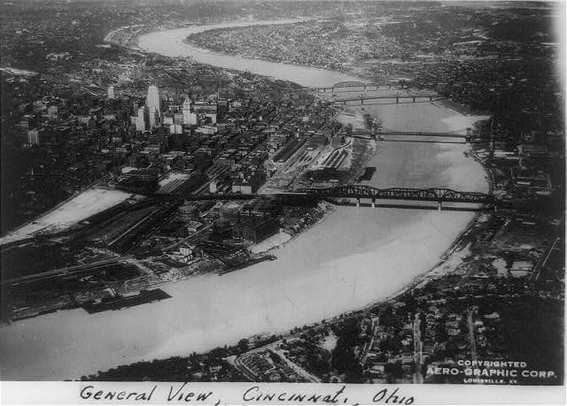
Student Reading 1.4: Cincinnati Then and Now
Cincinnati was not always known as Cincinnati. When it was first established, the city was actually called Losantiville. In 1790, the governor of the Northwest Territory established Hamilton County and changed the name to Cincinnati. Just a few years before this, in 1788, General Josiah Hamar established headquarters at Fort Washington in Cincinnati. From all of the money the army brought in, merchants quickly came into the community. When the army left Fort Washington in 1795, Cincinnati continued to grow due to its location on the Ohio River. During this time there were no roads, so rivers became they main form of travel. They were known as the great highways across America.
As a result of its location along the Ohio River, Cincinnati became known as a River City. Its access to water allowed many industries to grow and produce a variety of goods. Some of the goods produced were lumber, glass, iron casting, cloth, and meatpacking. Iron production was originally done in Northeastern Ohio, but for the early part of the 19th century, Southern Ohio became the dominate location for the industry. Cincinnati and Pittsburgh would send the iron up and down the Ohio River. Each city worked together to produce as much iron as possible. Meatpacking was another major industry in Cincinnati. Farmers would bring livestock to Cincinnati to be slaughtered and processed into meats to be sold at the marketplaces. However, because southern Ohio is very warm, the meat would spoil quickly, leaving the city with a horrible odor. Any meat not sold at the marketplace was dumped in the Ohio River. The people thought this would help to wash away the smell. Due to its location along the Ohio River Cincinnati become one of the most important cities in the west. It served as a large shipping port where goods where brought into the city and transported to other cities throughout the United States.
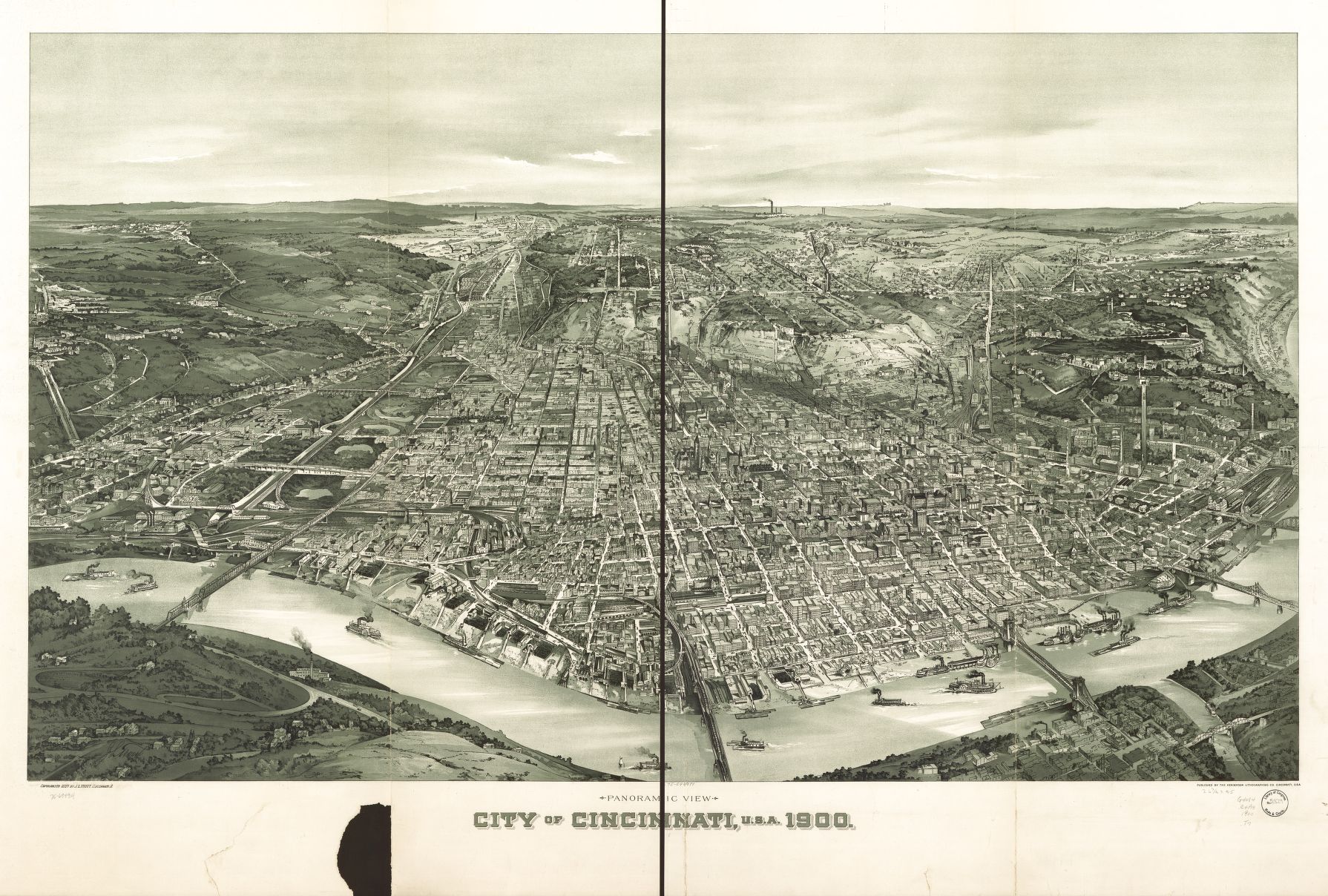
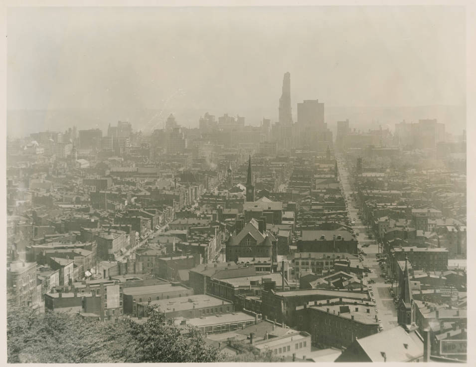
As Cincinnati continued to grow and become an important area of production and trade people began to improve the transportation systems which allowed goods to travel between cities. By 1851 three major railroads began operating in Cincinnati. They were known as: Sandusky-Mansfield-Newark, Cincinnati-Hamilton-Dayton, and Cincinnati-Cleveland. During the 1850’s, railroads dominated transportation across the United States as they allowed people and goods to travel farther distances. This helped Cincinnati’s businesses in the production of goods. Eventually the transportation systems and industries led to Cincinnati becoming the largest city in Ohio with 300,000 people.
During the 1900’s, the United States was expanding. With the help of railroads, the meatpacking industry moved out of Cincinnati and westward into cities like Chicago. Steamboats were replaced with barges that would carry coal and other materials. Along with this, suburbs were developing around Cincinnati causing the city to expand beyond the River front area. As a result, many factory owners moved their industry several miles outside of downtown Cincinnati in order to get more space.
After World War II, Ohio went through a major shift. Jobs transitioned to transportation, public utilities, wholesale and retail trades, finance, insurance, real estate, government, and professional occupation. By 1970, jobs around Cincinnati and Ohio switched to providing services rather than production of goods.
Student Reading 1.3: Cincinnati Grows and Changes
Thousands of years ago, Cincinnati did not exist. In fact, the area where we live now was part of a sea. Visit Cincinnati’s Bi-Centennial Commons at Sawyer Point and you will find a timeline that includes ancient fossils found in our area. These include fossils of plants and animals that only lived in the water! The Earth has changed a lot in all those years. This was a very big change that nature made to our local environment.
Of course, there are many other changes that have happened in our area. Some changes have been big and some small. Nearly all these changes have been made by humans. People make changes to their communities for many reasons. Usually, it is to help make the area better for those who live there.
In the beginning stages of our country’s development, Ohio was wilderness. A wilderness is land that has not been changed by humans. Native Americans lived in the area as long ago as 13,000 B.C. The Native Americans used the natural resources they found in the area to help them survive. They ate from plants that grew wild, they fished, and they hunted. The Fort Ancient people, who lived in the area over 800 years ago, are thought to be the first Native Americans to change the land by planting and growing specific foods. This was a reasonably small change.
In 1787, John Cleves Symmes bought two million acres of wilderness along the Ohio River. He sold pieces of it. In 1788, Israel Ludlow, Matthias Denman, and Robert Petterson bought eight hundred acres of the land, and this became the settlement of Losantiville. In order for people to build homes and businesses, the wilderness had to be cleared. This was a big change!
By 1790, Losantiville had grown, and it was renamed Cincinnati by the territory’s governor. Other small communities started nearby such as North Bend and Columbia. It was difficult to travel because there were not roads. Even in the early 1800s, travel in the area was still difficult. River travel, which was the best way for settlers to get across the vast wilderness, took time. If the water level in the river was low, the boats could not travel quickly. Eventually, roads and streets were constructed to make travel easier. This was a big change, and brought many other changes.
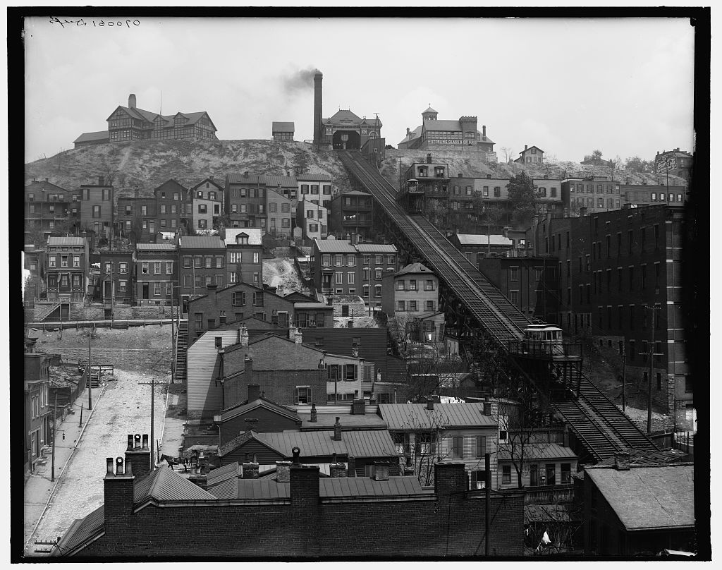
In the early days of Cincinnati’s settling, people lived near the river. As more people moved into the city, and it became crowded and dirty, people who had the ability to move away from the city center (which meant they had money), began to move up into the hills that surrounded the city. However, travel up and down the hills was difficult. A series of inclines was built to move people and goods up and down the hills. Now, those inclines are gone. What changes were made that allow people to easily travel around the city’s many hills today?
As a city grows, changes have to occur to meet the needs of the people who live there. In 1803, the population of Cincinnati was around one thousand people. By 1820, it had grown to around ten thousand people. Today, there are close to 297,000 people living in Cincinnati. Just like in those beginning days, people move to areas they find more appealing. That means our city has expanded over the years. There are many smaller communities that are a part of the larger city. For example, Avondale, Camp Washington, Clifton, Price Hill, Walnut Hills, Mount Lookout, and Northside are all a part of Cincinnati.
People have to travel from different parts of the city for work, school, and recreation. The city has built streets to allow travel by car and bus. In 2014, work on a new street car began to help people travel more easily in and around the downtown area. For these things to occur, land is often moved. Hills may be flattened, curves straightened, or routes made to go around places, like businesses, parks, or homes that people do not want moved or destroyed. Think about all the bridges that cross the Ohio River near Cincinnati’s downtown. These changes have been both big and small and have allowed travel and growth all over the area.
Cincinnati has grown in population and in the amount of space that is taken up by people, homes, businesses, and recreation areas. In the beginning, eight hundred acres, or 1 ¼ square miles, was purchased for the new settlement. In 2014, the amount of area taken up by Cincinnati is just about 80 square miles. That’s a big change!

Student Reading 1.2: Cincinnati and Geography – Reading a Map

The map of Ohio is called a Political Map. A Political Map is a map that shows the boundaries of states, cities, and countries. While this map is black and white, these maps can come in many different colors. Around this map is an Alphanumeric Grid, which is a grid of numbers and letters that help locate places on a map. The boxes that are labeled from one to six, and go from top to bottom, form rows. Boxes that go from left to right and are labeled with letters form columns. To locate Cincinnati on this map, first find and place your finger on the point in front of the word Cincinnati. Look to your left, the number of the row where we find Cincinnati is labeled number five. Next, look up to the top of the column where you find Cincinnati. The column where it is located is labeled B. So, we would tell someone to look in box 5B to find Cincinnati.
Another type of map that you will use when traveling is called a Physical Map. This is a map that focuses on the geography of an area. Map makers use mainly colors like green, blue, and brown to show landforms like mountains, rivers, and lakes. A Map Key is very important when it comes to reading a physical map. This key will tell you what each symbol stands for on the map. The map key can also be called a legend. Different landforms you may see on a physical map include mountains, plains, plateaus, boundaries, and different types of water ways. A physical map of Ohio would probably show the Ohio River and where the bordering states of Kentucky, Indiana, Michigan, Pennsylvania, and West Virginia. If you look at the map key on the map of Ohio, the city marked with a star is the capital city of Ohio. Can you locate the capital city of Ohio?
Now, using the map of Ohio, take some time to locate the cities of Toledo, Cleveland, and Columbus. Now look at the Compass Rose located at the bottom of the map on the hand side. This is a tool that can be used to show the four main cardinal directions. Look at the map; you can see Cincinnati is in the south. What city is located to the northeast of Cincinnati? Cleveland and Toledo are located in the northern part of our state. If you had to tell someone where to find these two cities, you could tell them that Toledo is in the northwest part of the state while Cleveland is located in the northeast.
Student Reading 1.1: What are Maps For?
Early Saturday morning Mom called upstairs to Jimmy, “Jimmy, we have to get going. Today is the day we are off on our adventure!” Jimmy had been excited all week to begin their trip – they were driving to Tennessee to see his grandparents. It would take them several hours of driving to get there. Jimmy was a little bit worried about being bored on the long drive. He took his suitcase down to the car, got settled in and fastened his seatbelt. And they were off!
Mom sat in the front seat next to Dad, who was driving, and Jimmy sat in the back seat. He started reading the book he had brought along. He could hear Mom giving Dad driving directions. After about an hour of driving, Jimmy put his book down. When he looked out the window, he saw they were in the countryside, far from the buildings and roads with which he was familiar. “Mom, how do you know we are going the right way?” Jimmy asked. “I am using this map.” Mom replied. She handed Jimmy a very large piece of paper with lots of lines and words all over it. Jimmy looked at it for several minutes, but nothing seemed to make sense. He saw letters and numbers and names and symbols, but they all seemed to jumble together. “Mom, this thing makes no sense! How is it helping you?”
“Well, Jimmy,” mom explained, “this map shows all the roads we will use to get to Grandma and Grandpa’s house. It helps me decide where to turn, and how far to go.” Jimmy looked again at the paper in his hands. “How do you know that’s what it shows?” he asked his mom. “Well, first, I can tell it shows the section of the country that I want it to by looking at the title. See how this one is titled, “Ohio/ West Virginia”? That tells me it is the map I need. I can find the street where we live on the map, then find the street where Grandma and Grandpa live, and find the best route to get from one to the other.” Jimmy looked at the map, trying again to make sense of it. He saw the word “Cincinnati”, so he knew his house was somewhere in that section of the map, and he saw the word “Parkersburg”, which he recognized as the city where his grandparents lived, so he knew their house was somewhere in that map section. “Okay, so I can see that. But how do you know which way to turn?” Jimmy asked Mom. “Well, look down in the bottom corner of the map. Do you see that cross-shaped figure? That is a compass rose. It shows the cardinal directions of north, east, south and west. That tells me that we need to drive to the east to get where we want to go.” “Oh, that makes sense. But what the heck is this little picture here?” Jimmy asked as he pointed to a small drawing on the map that looked like a group of trees. “Well, if you need to know what a symbol on the map stands for, you look at the map key.” Mom said. “It has the definitions for each symbol.” Jimmy looked at the map key and found that the symbol of trees showed where there was a state or national forest.
“Okay, this is starting to make a lot of sense. But you said you found our street on this map. That must have taken a long time! There are a lot of streets here. How did you know where to look?” “Oh, well, do you see the letters and the numbers along the edges of the map? They really help me find things. Here, you try it. On the back of the map there is an Index, just like one you might find in a book. Here you can look up our street name. Try it and let me know what you find.” Jimmy looked through the ‘F’ listings until he found the name of his street – Flowerwood Court. Next to the name he saw B4. When he told his mom this information, she showed him how to find the B column across the top of the map and put his right index finger there, and then find the 4 row along the side and put his left index finger there. He then slid his fingers along the column and row until his fingers met in a square that had been drawn onto the map. “Now look in that square and you will find our street.” Mom said. Jimmy looked carefully, and saw that Mom was right! “This is called an alphanumeric grid, Jimmy. ‘Alpha’ means a letter and ‘numeric’ means a number. You use both a letter and a number to find the right square on the map.” Jimmy spent about an hour finding things that were familiar to him on the map, and identifying what grid square contained familiar locations. He looked up his school, his church, and friends’ houses. Before he knew it, it was time to give the map back to Mom so they could find the way to Grandma and Grandpa’s house. This long drive had not been boring at all! Jimmy couldn’t wait to spend more time exploring maps.
- 1
- 2